The Beautiful Mountains of Perú
Mountains Of Perú:
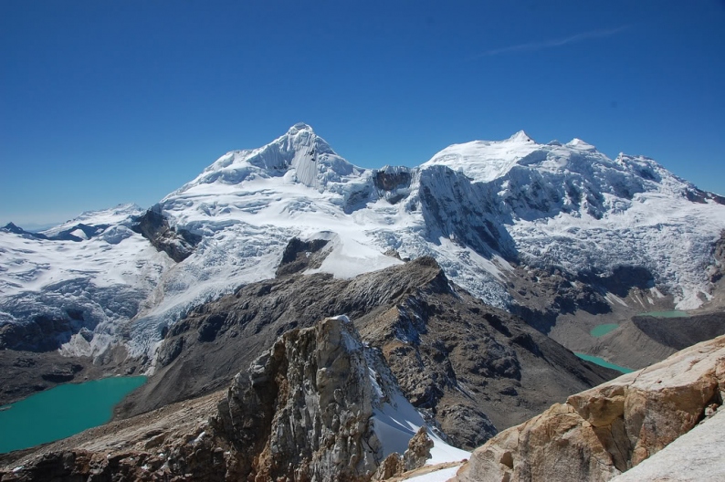
- Huascarán
- Yerupajá
- Mount Coropuna
- Ausangate Mountain
- Huantsan
- Chopicalqui
- Siula Grande
- Snowy Chinchey
- Ampato
- Palcaraju
- Salkantay
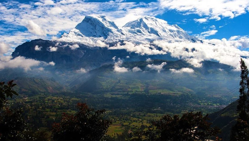
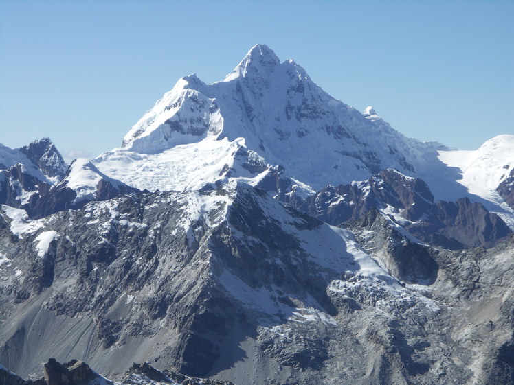
1. Huascarán
Surpassed only by the Aconcagua, Ojos del Salado, Pissis and Mercedario peaks.
If the measurement is formed from the middle of the world , it's the second highest mountain on the earth after the Chimborazo volcano, surpassing the peak of Everest by almost two kilometers
In 2013 a team of Australian and German researchers revealed that it's the place on the surface with the smallest amount gravitational pull
The massif occupies the central area of the Cordillera Blanca and is separated from the remainder of the chain by two deep valleys: the Llanganuco ravine to the north and therefore the Ulta ravine to the south.
Geographic depressions that house the Llanganuco lakes: Chinancocha and Orconcocha, and therefore the highest vehicle tunnel within the world:
The Punta Olímpica Tunnel, located at 4736 m above water level . the closest populated cities are Carhuaz and Yungay, located about 15 km from the mountain.
2. Yerupajá
It is located on the border of the departments of Ancash, Huánuco and Lima.
Its popular name is El Carnicero, being this the second highest altitude in Peru, it's however very difficult to climb it thanks to its almost vertical edges and walls, making it ideal for the practice of professional mountaineering.
Seen from a distance, the Yerupajá is gigantic in reference to the opposite snow-capped mountains that structure the Cordillera. Its eastern wall, which is that the steepest, corresponds to the district of Queropalca, province of Lauricocha within the Huanuco region.
Its imposing edges are visible from Conococha, Chiquián, heights of Mina Llipa, Cajamarquilla, Rondos, Queropalca and from points on an imaginary radius circumference of 60 km, at an altitude of 4000 meters above water level .
The western face are often seen from Chiquián, it's the form of an axe whose edge, which is that the summit, gives the impression of bisecting the firmament into two infinite blue parts.
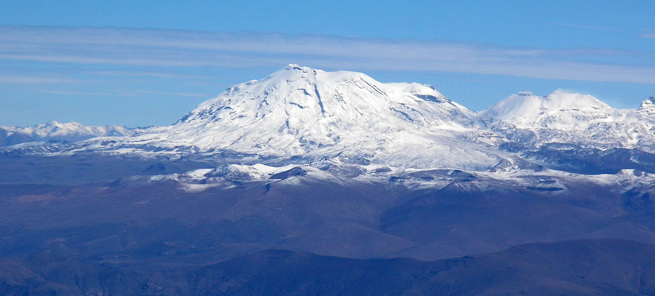
3. Mount Coropuna
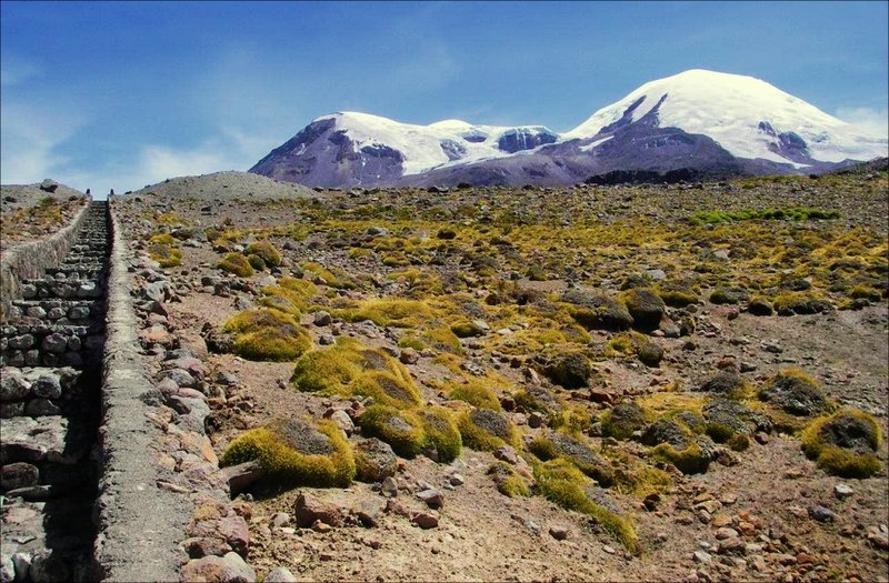
The Coropuna is a stratovolcanic complex of approximately 1000 km² in the Ampato de los Andes mountain range in southern Peru, located in the district of Viraco, province of Castilla and in the district of Salamanca (Condesuyos), province of Condesuyos in the department of Arequipa.
With an altitude of 6425 meters above sea level, it is the highest volcano in Peru and the third highest in the country, after the Huascarán at 6768 meters above sea level and the Yerupajá at 6634 meters above sea level.
It is formed by a volcanic building of six cones and three lava flows from the Holocene era. At present, its summits are covered by a glacial system of 50 km² with several dozen glacial tongues descending its slopes, in a radial fashion.
It is supported by a partially dismantled Lower Pliocene structure of truncated cone shape, ranging from 4200 to 5000 meters in altitude.
On top of this basal structure, throughout the Upper Pliocene and Pleistocene, successive volcanic eruptions have been superimposing materials until forming a set of six coalescent buildings whose summits, in many cases, exceed 6000 metres in altitude
It was one of the most important ritual centers of the Tawantinsuyu, who called it huaca, "worshipped" it (Andean offerings of reciprocity) for its eminence and beauty.
For a long time, because of its volume and proximity to the sea, sailors saw it and believed that it was the highest mountain on the continent. To prove this belief and because of the archaeological remains in its surroundings, Hiram Bingham (world-wide diffuser of Machu Picchu), explored it in 1911.
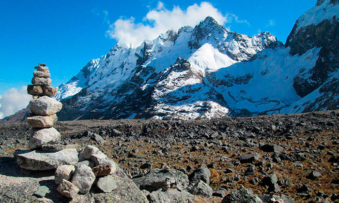
4. Ausangate Mountain
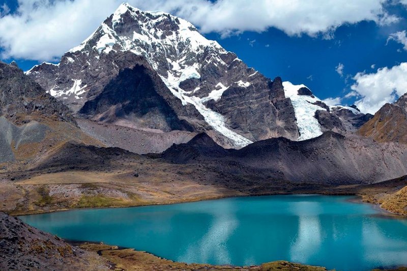
It is located within the Andes, during a stretch called the Vilcanota range , like the region of Cusco in Peru. Its main peak is at 6,384 meters above water level with large lakes with a luminous green/blue color.
In the Inca mythology of this mountain and therefore the nearby lakes - among which Sibinacocha stands out - the masculine energy is born that fertilizes the mother earth Pachamama; after an extended run, the waters are lost within the unknown lands of the Amazon to return to fill the lakes and therefore the glaciers nightly converted into the river of stars or Willkamayu known within the west because the Milky Way .
The community of Chillca, made from llama and alpaca herders, is understood because the guardian of those pristine places, from where you'll continue mountain walks and spend the night in comfortable lodges or tambos, among which Machuracay Tambo stands out, on a walk called "Camino del Apu Ausangate".
Every year on the northern side of Ausangate the festival of Qoyllur Rit'i (Quechua: "star snow") has been celebrated since time out of mind before the feast of Corpus Christi, during which thousands of Quechuas make a pilgrimage to the Lord of Quyllur Rit'i within the temple of Sinakara (painting on a rock).
This pilgrimage was included within the Representative List of the Intangible Cultural Heritage of Humanity.
The Ausangate mountain hike is taken into account adventure tourism. the trail presents rock formations at a height of quite 5 thousand meters covered by tongues of ice.
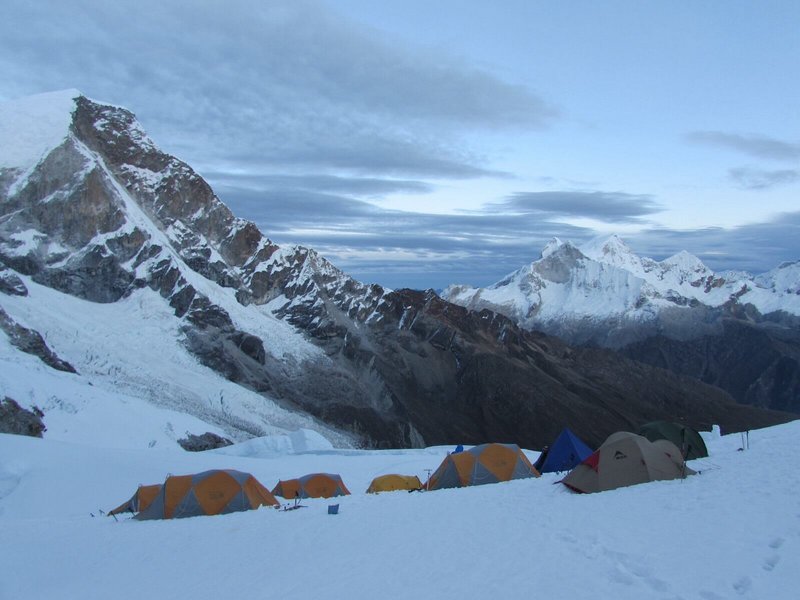
5. Huantsan
Huantsan may be a mountain in Peru. it's the third highest peak within the Cordillera Blanca and therefore the fourth within the department of Ancash. it's located 24 km east of the town of Huaraz. it's an altitude of 6 370 m
The Huantsán consists of 4 summits, the Huantsán itself (6,370 m), the Huantsán West (6,270 m), the Huantsán North (6,115 m) and therefore the Huantsán South (5,915 m).
It is considered "the K2 of the Andes" and its east face remains virgin until lately .
Also like most of the opposite snowy mountains of the Cordillera Blanca it's a part of the Huascaran park
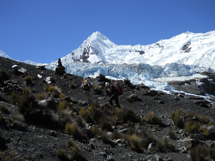
You can get from Huaraz to the foot of the Huantsan on each day trip with a all-terrain bike . Approximately 6 km south of the town , a secondary unpaved road is diverted from the most road towards the town of Macashca (9°″S 77°29′30).
Rajucolta Lagoon at the foot of Huantsan snow-capped mountain, seen from the control dam. From Huaraz there also are minibuses to the village. From Macashca a gravel road leads along the Quebrada Rajucolta to the lake at the foot of the mountain, the Laguna Rajucolta.
At an altitude of about 4000 m the border of the park is reached. A visitor's ticket is required, which may be obtained in Huaraz and is valid for several accesses.
It is also possible to access the foot of the east face of Huantsán from Chavín de Huántar. The hike can last from 3 to 4 days entering through the Alhuina ravine, where the Huachezca or Mariash rivers flow. Then you continue through the Quebrada Huantsán, crossing the Santa Rosa pass (4,850 m) to descend through the Quebrada Carhuascancha to the town of Huántar
t is also possible to access the foot of the east face of Huantsán from Chavín de Huántar. The hike can last from 3 to 4 days entering through the Alhuina ravine, where the Huachezca or Mariash rivers flow. Then you continue through the Quebrada Huantsán, crossing the Santa Rosa pass (4,850 m) to descend through the Quebrada Carhuascancha to the town of Huántar
6. Chopicalqui
The Chopicalqui (in Ancient Quechua: Chawpikallki) is that the third peak of the Huascaran range , located within the Cordillera Blanca, between the 2 peaks of Huascaran and Contrahierbas, within the province of Yungay, Peru.
With an altitude of 6,355 meters above water level , it's the fifth highest mountain within the department and therefore the fourth within the Cordillera Blanca.
Its name comes from the quechua chawpi ('center', within the regional quechua of Huaylas choopi, pronounced ) and kallki ('encañada', ravine, narrow pass),4 so its name means "encañada to the center".
First Expeditions :
Mexico: First Mexican ascent in 1981 by José Luis González, Nabor Castillo, Antonio Carmona, Guillermo Álvarez del Castillo, Jesús Álvares del Castillo and Vicente Hinojosa Alcalá.
7.Siula Grande

Siula Grande may be a mountain within the Cordillera Huayhuash, within the Peruvian Andes, on the border of the departments of Lima and Huánuco.
it's an altitude of 6,345 m and a secondary peak called Siula Chico of 6260 m
The mountain became famous due to the book Touching the Void by mountaineer Joe Simpson, which tells the story of the ascent and unsafe descent of the mountain that he starred in along side Simon Yates in 1985. In 2003 a movie with an equivalent title was made supported the book.
Although Simpson and Yates climbed the west face, being the primary to ascend to the summit by that route, for his or her descent they chose the north ridge (this route was first utilized in 1936 by a German team), the descent was extremely difficult partially due to the inclement weather.
All the climbers after them have avoided the ridge and abseiled down the west face. Until 2002 the south face had not yet been beaten.
The Siula Chicó may be a secondary peak of the Siula Grande at about 6260 m, separated from it by a pass (coll) at about 6000 m.
Mountaineers consider that the simplest route to its summit is thru the Siula Grande, and, in fact, it's by this route that it had been conquered by Manfred Sturm's expedition in 1966.2 In May 2007, Spanish mountaineers Jordi Corominas and Oriol Baró made the primary ascent of the Chico on the west face, in what was the second ascent of the
8. Snowy Chinchey
The Chinchey (in Ancient Quechua: Rurichinchay, 'Hidden Puma')?, may be a snowy massif within the Cordillera Blanca within the Peruvian Andes.
it's five peaks, the very best of which, also called Chinchey, is 6,310 meters high, making it the sixth highest mountain within the Cordillera Blanca and therefore the ninth highest in Peru. Its summit was conquered on August 2, 1939 by German climbers.
The massif acts as a natural boundary between the provinces of Huaraz, Huari and Carhuaz, within the Peruvian region of Ancash; however, the very best peak is merely shared by Huari and Huaraz. Geographically it's located over the natural janka region within the Cordillera Blanca, a range belonging to the Western Cordillera of Peru and guarded by the Huascaran park .
it's five peaks: Chinchey with 6.310 masl, Pamparaju with 5.985 masl, Puntacuerno with 5.960 masl, Ayukaraju with 5.645 masl and Utsaraju with 5500 masl.
The first to succeed in the summit of Chinchey Peak were Walter Brecht and Hans Schweizer on August 2, 1939, ascending the northern ridge during the exploration campaign of the Cordillera Blanca directed by Hans Kinzl with the collaboration of the members of the German Alpine Club.
In 1967, when the members of a Basque-Navarre expedition arrived within the area, just one of the three peaks of the northern ridge had a name: the Pamparaju.
Between June and July the expedition reached the summit of the three peaks, naming the last two as Ayucaraju (5647 m) and Utsuraju (5500 m). during a photo published by the Peruvian newspaper El Comercio, the climbers celebrate the summit by holding the separatist Ikurriña flag on one among the peaks.
This led to the arrest of the climbers once they returned to Spain during the dictatorship of Franco , and later expulsion from the mountain associations of the peninsular country.
In 1982, during an expedition to Nevado Purisima, a series of photographs were taken of the Chinchey Massif showing Puntacuerno for the primary time, the last peak that had not yet been climbed.
to realize the ascent of what might be the last 6000 inviolable, the Peruvian climbers Américo Tordoya and Augusto Ortega climbed the east wall from the Chalhuacocha lagoon and, after a final stretch the northeast ridge, they reached the summit on August 21, 1983.
Today, there are two well travelled routes: the west route, of difficulty level (AD) (only for knowledgeable climbers), from the bottom camp at 5100 meters above water level accessing by the Quilcayhuanca ravine; and therefore the north route, of lesser difficulty, climbing directly from the Pucaranracocha lagoon
9. Ampato
The Ampato (from the Aymara jamp'atu, 'toad') is a dormant volcano located in the Ampato mountain range in southern Peru, in the district of Lluta.
It has an altitude of 6,290 meters above sea level. Near the summit of this snow-capped mountain, a frozen corpse was discovered in September 1995 by mountain archaeologist Johan Reinhard and climber Miguel Zarate.
This female mummy is known as Juanita, the Lady of Ampato or the Lady of Ice. During expeditions led by archaeologists José Antonio Chávez and Johan Reinhard in October 1995 and December 1997, three Inca mummies were found at 5,850 m.
The Ampato volcano has two summits, the north, over 6150 m, and the south and main, at 6290 m. equally known as the kingdom of the ducks
It belongs to the Ampato mountain range which, together with the Volcanic range and the Chila, forms part of the three main mountain ranges of the department.
The volcanoes that surround it are the Sabancaya and the Hualca Hualca.
Snowy climate, with temperatures below 0 °C. There are permanent snowfalls, blizzards, storms and hail.
10. Palcaraju
The Palcaraju (in Ancient Quechua: Pallqa rahu, 'Forked or Branched Snowy')?, is a snowy mountain in the Cordillera Blanca in the Peruvian Andes.
At 6,275 meters, it is the seventh highest mountain in the Cordillera Blanca and the eleventh highest in Peru.
Besides the main peak, it has three more peaks: Palcaraju East (6,180 m), Palcaraju West (6110 m), Palcaraju South (5900 m). Its summit was conquered on June 7, 1939.
Politically, the snow-capped mountain is located in the province of Huaraz in the Peruvian region of Ancash. Geographically, it is located on the natural region of Janka in the Cordillera Blanca, a mountain range that belongs to the Western Cordillera of Peru and is protected by the Huascaran National Park.
The snowy massif of which it is part is the Chinchey. The closest peak to the Nevado Chinchey (6,310 m), is located 5 km to the east. The nearest city is Huaraz, about 25 km to the southwest in the Callejón de Huaylas
It has four summits joined by an edge with vertical chasms on each side, the central summit is the highest point of the group with 6,275m
In 1939, an expedition of the German Alpine Club made up of Walter Brecht, Siegfried Rohrer, Karl Schmid and Hans Schweizer conquered the summit of the mountain after choosing as their route of ascent the northern side, whose glacier descends to the Pacllash Lake
The central summit can be reached by 6 routes catalogued as difficult (D) to Extremely Difficult (ED). The latter was opened by Slovenian climbers (P. Poljanec and Z. Trusnovec) who climbed the western ridge from the Ishinca.
While the Palcaraju West has only one route, and the Palcaraju South has two opened by the French Nicolas Jaeger in 1977, ascents made in solitary style.
In 1987, a Slovenian made the first crossing from the central summit to the south through the snow crown
11. Salcantay or Salkantay
The Salcantay or Salkantay (in Quechua, Sallqantay) is a snow-capped mountain in Peru, located in the Vilcabamba Mountain Range, in the district of Santa Teresa, province of La Convención, department of Cusco. It rises to 6264 m above sea level.
The Salcantay snow-capped mountain is one of the highest mountains in the Cusco region, along with the Ausangate snow-capped mountain in the Vilcanota mountain range which is located further south.
However, it is considered the greatest in its splendid isolation and the grandeur of its two-headed mass. It is also one of the mountains in the Andean region that presents the greatest technical problems, in all its aspects, for sport climbing. The six itineraries opened up to date by the different slopes of this mountain testify to this.
It was conquered in 1952 by the Swiss team of Bronimann and Marx.2 This first ascent, like so many others in the history of mountaineering, is surrounded by various contradictions, since a few days later it was climbed again by a French-American expedition that included the renowned mountaineer of the time, Claude Kogan.3 New statistics gave the Italian Consuelo Bonaldiel the merit of being the first woman to reach the summit of Sancantay on August 4, 1978. Together with G.Marconi, A. Mangononi, F.Nodari, S.Castellani, Augusto Zanotti and M.Quatrinni they reached the western ridge. This fact is controversial since Claude did it 26 years before.4
The summit of Salcantay has two peaks, the East and the West. Formerly the West, more slender and attractive than the East was slightly higher as it was crowned by a serac. After the passage of time and the collapse of this serac, as noted by the prestigious Pyrenean Louis Audoubert, the height is almost identical on both peaks.
What happened in those two consecutive "first ascents" gave rise to the controversy of which had been the real first.
The Swiss climbed the East summit in the fog (the lowest in those days), the Americans however climbed the West, which was somewhat higher so that the statistics, always relentless, want to deny Bronimman and Marx their first absolute ascent.
As a culmination of his well-deserved reputation as a difficult summit, in 1953 he was ascended for the third time by the prestigious Alpine guide Lionel Terray, who together with the Dutchman T.de Booy and the Swiss Raymond Jenny, conquered the summit by following a route along the North Spur, known today as the Terray Spur.


Total flexibility
Change of plans? It's okay, you can cancel most of book free of charge up to 24 hours before the activity. If you need us, our customer service is available 24 hours a day, 7 days a week